|
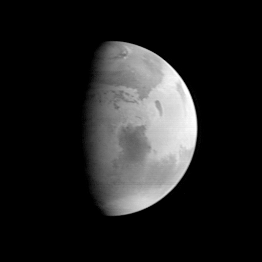
This image was acquired by the Mars Global Surveyor (MGS) Mars Orbiter Camera (MOC) on August 20, 1997, when MGS was 5.51 million kilometers (3.42 million miles) and 22 days from encounter. At this distance, the MOC's resolution is about 20.6 km per picture element, and the 6800 km (4200 mile) diameter planet is about 330 pixels across. North is at the top of the image. The MGS spacecraft pointed the camera at the center of the planet (near the dark, morning sunrise line, or terminator) at 23.6° N, 307.3° W. The irregularity of the terminator seen in this image results from contrast processing. This image shows the prominent dark feature Syrtis Major, believed to be a relatively dust-free area of bedrock outcrop and sand dunes. The large Hellas impact basin (2000 km or 1250 miles across) is seen at the bottom of the picture. Clouds from the south polar region fill the basin. The north polar residual ice cap, surrounded by a dark annulus of sand, is seen at the top of the picture. |
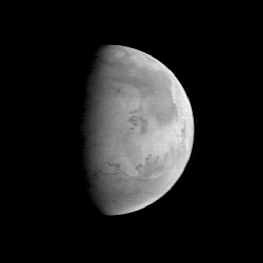 |
The Mars Orbiter Camera (MOC) took this image on August 20, 1997, when the Mars Global Surveyor (MGS) was 5.67 million kilometers (3.52 million miles) and 22 days from entering orbit. At this distance, the MOC's resolution is about 21.2 km per picture element, and the 6800 km (4200 mile) diameter planet is about 327 pixels across. North is at the top of the image. The MGS spacecraft pointed the camera at the center of the planet (near the dark, morning sunrise line, or terminator) at 23.6° N, 82.1° W. At this distance from Mars, only bright and dark markings resulting from variations in the amount and thickness of dust and sand are visible. The large dark marking stretching from the right center northward is Acidalia Planitia, a region of rock and sand with less dust on it than the area immediately to the south, Chryse Planitia. Both Viking Lander 1 and Pathfinder landed in the latter, bright area. In this low resolution image, some of the dark features resemble the "canals" seen prominently in maps created by astronomers of the 19th and early 20th century. Mariner 9 and Viking images show that most of these dark lines are associated with sand deposits that are trapped in rough areas. |
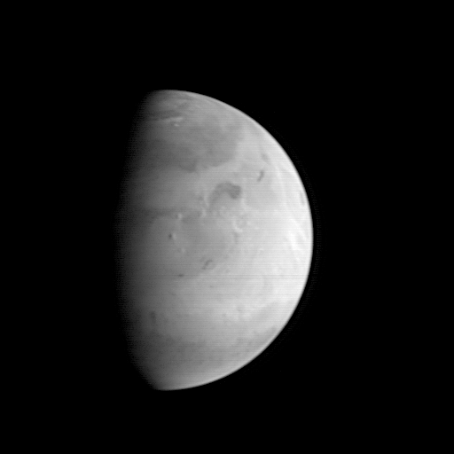 |
This Mars Orbiter Camera (MOC) picture shows the Elysium region of Mars as it appeared from the Mars Global Surveyor (MGS) spacecraft on on August 20, 1997. At the time, MGS was 5.57 million kilometers (3.46 million miles) and 22 days from Mars, and the picture has a resolution is about 20.8 km per picture element. Mars, 6800 km (4200 mile) in diameter, is about 327 pixels across. North is at the top of the image. The camera was pointed at the center of the planet (near the dark, morning sunrise line, or terminator) at 23.6° N, 217.4° W. At this distance from Mars, only atmospheric phenomena (clouds and fogs) and bright and dark markings resulting from variations in the amount and thickness of dust and sand are usually visible. However, in this view the shading of the relief of the three Elysium volcanoes (from north to south Hector Tholus, Elysium Mons, and Albor Tholus) can be seen owing to their position close to the terminator. Elysium Mons, the center-most volcano, is estimated to be 12,000-14,000 meters (39,000 to 46,000 feet) high. |
Malin Space Science Systems and the California Institute of Technology built the Mars Global Surveyor Orbiter Camera (MOC) using spare hardware from the Mars Observer mission. MSSS operates the camera from its facilities in San Diego, CA. The Jet Propulsion Laboratory operates the Mars Global Surveyor spacecraft with its industrial partner, Lockheed Martin Astronautics, from facilities in Pasadena, CA and Denver, CO.

|
This movie (3921K) was created by combining the eight MOC MOI-22 day approach images into a map of Mars, and then digitally reprojecting that map onto a sphere. This is the same process used by the Hubble Space Telescope team in making its rotation movie from HST data (699K). The HST data were acquired when Mars was viewed more or less "face on," whereas MOC viewed the planet at half-phase. Thus, each of the eight MOC images required processing to remove the overall shading (the photometric function). Software provided by the Hubble Space Telescope Mars Monitoring team was used for this purpose. This software was also used to create a map projection of each image. These were then mosaiced together to create a map of the visible part of the planet (areas south of 66.4°S were not ever seen). Owing to foreshortening in the polar regions, some cosmetic processing was needed in areas south of about 35°S as well. Once the final map was created, a limited amount of enhancement was applied to sharpen features, and the resulting image was "mapped" onto a sphere using computer graphic software. A camera within this software was place at a relative distance and appropriate magnification to recreate the view seen from MGS, and an illumination source was set at the right location to simulate the sun. A set of test images were then created to compare with the original images. When the simulation recreated the input images, the rotation of the planet was simulated, and the camera position moved to observe the planet "face-on." |
