
(2 Mbytes)
|
This image montage shows every lander image obtained from
the rover Sojourner. Beneath each image are the Sol the images were taken.
(2 Mbytes) |
 |
This image montage shows every rover Alpha Proton X-Ray Spectrometer (APXS) deployment prior to Sojourner's entry into the "Rock Garden." The labels beneath each image are APXS measurement catalog numbers. Those not listed, such as A-1, were background measurements of the ambient Martian environment. |
  |
Left and right images of Sojourner traversing near Half Dome. |

August 25 (Sol 52) |
This movie (802 K) shows the Sojourner rover positioning itself near the rock "Shark" on Sol 52. The rover's Alpha Proton X-Ray Spectrometer was successfully deployed on to Shark that evening. |
August 12 (Sol 39) |
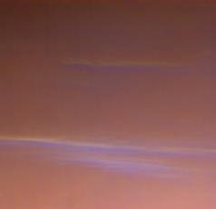
These clouds from Sol 39 have a new look. As water ice clouds cover the sky, the sky takes on a more bluish cast. This is because small particles (perhaps a tenth the size of the Martian dust, or one-thousandth the thickness of a human hair) are bright in blue light, but almost invisible in red light. Thus, scientists expect that the ice particles in the clouds are very small. The clouds were imaged by the Imager for Mars Pathfinder (IMP). The bright clouds near the bottom are about 10 degrees above the horizon. The clouds are believed to be at an altitude of 10 to 15 km, and are thought to be made of small water ice particles. The picture was taken about 40 minutes before sunrise. |
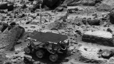
August 20 (Sol 47) |
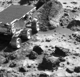
Left and right images of the Sojourner rover perched atop Wedge rock during Sol 47. Sojourner has safely traversed off of Wedge and is now the vicinity of Shark rock where it will perform additional APXS measurements. In these images the vantage point of the IMP camera provides a view looking into the throat of the APXS. The APXS is the round object in the center of the front surface of the rover. |
August 20 (Sol 47) |
A view of flat top rock from Sol 47. |
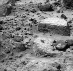
August 20 (Sol 47) |
The Sojourner Rover backing up toward Flat Top and away from Wedge. |
August 20 (Sol 47) |
A close up view of Flat Top. |
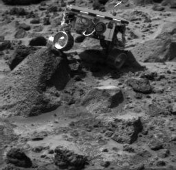
August 17 (Sol 44) |
Mosaic of Wedge, Shark, Half-Dome, Moe and Flat Top The front cameras aboard the rover Sojourner imaged several prominent rocks on Sol 44. The highly-textured rock at left is Wedge, and in the background from left to right are Shark, Half- Dome, and Moe. The rectangular rock at right is Flat Top, which earlier close-up images revealed to be made up of elongated pits, possible made by vesicles from volcanic outgassing or etches caused by weathering. |
August 12 (Sol 39) |
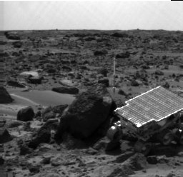
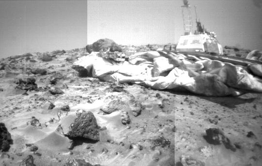
Rover camera mosaic of lander & WedgeThis mosaic of the Mars Pathfinder lander and Martian terrain was taken by the front camera on the Sojourner rover on Sol 39. The rover, positioned near the rock "Wedge" at left, has imaged the the letters "JPL" and the American flag mounted on the side of the lander's electronics box. A large spread of deflated airbags are strewn around the lander's periphery, and the large rock Yogi, studied earlier in the mission by Sojourner's Alpha Proton X-Ray Spectrometer instrument, lies behind the airbags in the background. The front rover deployment ramp is at right, while the Imager for Mars Pathfinder mounted on its mast stands high at the top of the lander's electronics box. |
August 17 (Sol 44) |
Sojourner at WedgeThis image, taken by the Imager for Mars Pathfinder (IMP) at the end of Sol 44, shows the Sojourner rover heading toward a rock called "shark". Sojouner's left front wheel is jutting up against the side of Wedge, at left. The stowed Alpha Proton X- Ray Spectrometer (APXS) instrument can be seen on the rear of the rover. |

Sols 20 and 38 |
This preliminary enhanced color image mosaic of the area
northeast of the lander was made using images acquired in the afternoon
of Sol 20 (top portion of the mosaic) and Sol 38 (bottom portion of the
mosaic) by the IMP camera as part of the Super-Pan data set. The differences
in brightness between the upper and lower portions of the mosaic result
from slightly different sun angle positions between Sols 20 and 38, and
can be compensated by subsequent analysis of the reflectance of surface
rocks and soils under different lighting conditions.
At each camera frame position, a Super-Pan image contains fifteen frames---six frames for three-color stereo and nine more individual narrow color bands. This mammoth color and stereo data set will be used to derive high quality topographic maps of the surface and detailed shapes of rocks and other surface features, and to map subtle chemical, mineralogical, and textural variations on rocks and soils. Red, green, and blue filter images from the right eye were combined to simulate slightly amplified natural color. The bright, flat areas Scooby Doo and Baker's Bench are visible left of center and above center in the mosaic, respectively. Airbags and a portion of one of the lander petals are visible in the foreground. The processing of this mosaic was done by the United States Geological Survey, Flagstaff, Arizona. |
August 8 (Sol 35) |
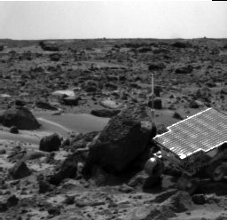
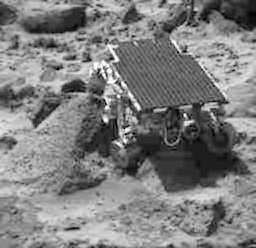
Sojourner moving closer to Wedge This image, taken by the Imager for Mars Pathfinder (IMP) at the end of Sol 35, shows the Sojourner rover heading toward a rock called "Wedge." The stowed Alpha Proton X- Ray Spectrometer (APXS) instrument is at the rear of the rover towards the rock. |
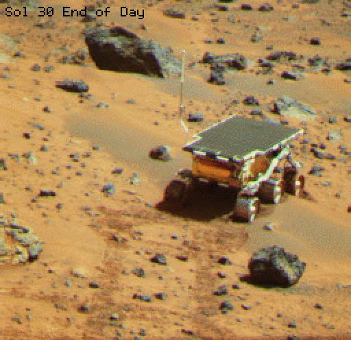
August 3 (Sol 30) |
Sojourner at Mermaid DuneThis color image of the Sojourner rover was taken at the end of day on Sol 30. The rover is perched atop Mermaid Dune, a dark material distinct from the surrounding bright surface. Dark red rover tracks extend from the foreground to the base of the rover's wheels. |
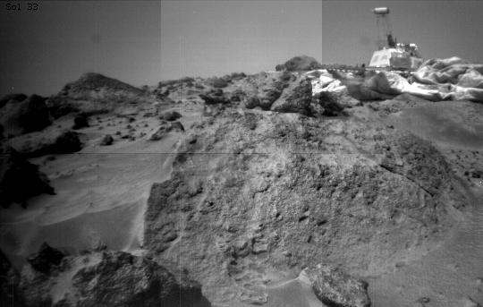
August 6 (Sol 33) |
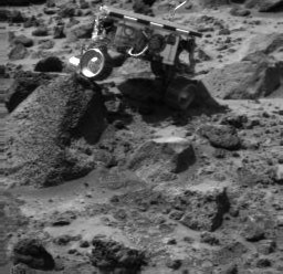
Pitted Rock Named EnderThis image was taken by the Sojourner rover's right front camera on Sol 33. The rock in the foreground, nicknamed "Ender," is pitted and marked by a subtle horizontal texture. The bright material on the top of the rock is probably wind-deposited dust. The Pathfinder lander is seen in the distance at right. The lander camera is the cylindrical object on top of the deployed mast. |

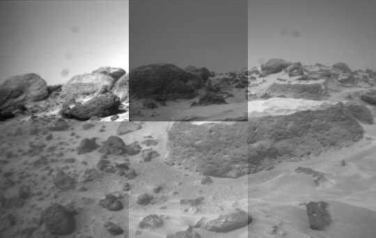
Sol 32 |
Super-pan octant S0184 This enhanced color image mosaic
of the Rock Garden area west of the lander was made using images acquired
in the mid-morning of Sol 32 by the IMP camera as part of the Super-Pan
data set.
At each camera frame position, a Super-Pan image contains fifteen frames---six frames for three-color stereo and nine more individual narrow color bands. This mammoth color and stereo data set will be used to derive high quality topographic maps of the surface and detailed shapes of rocks and other surface features, and to map subtle chemical, mineralogical, and textural variations on rocks and soils. Red, green, and blue filter images from the right eye were combined to simulate slightly amplified natural color. The "bookshelf" rocks visible in the background include Shark, Half-Dome, Moe, and Stimpy. The rover Sojourner completed imaging and APXS measurements of these rocks on Sol 71. Small rocks below and to the right of Flat Top appear to have been moved and/or pushed into the soil, probably by the spacecraft during landing. A portion of South Peak is visible in the upper right corner of the mosaic. One of the solar-panel-covered lander petals and the forward rover ramp are visible in the foreground. The Processing of this mosaic was done by the United States Geological Survey, Flagstaff, Arizona. |

Sol 31 |
This enhanced color image mosaic of the area south of the
lander was made using images acquired in the mid-morning of Sol 31 by the
IMP camera as part of the Super-Pan data set.
At each camera frame position, a Super-Pan image contains fifteen frames---six frames for three-color stereo and nine more individual narrow color bands. This mammoth color and stereo data set will be used to derive high quality topographic maps of the surface and detailed shapes of rocks and other surface features, and to map subtle chemical, mineralogical, and textural variations on rocks and soils. Red, green, and blue filter images from the right eye were combined to simulate slightly amplified natural color. The rocks Squid, Ender, Hassock, and a portion of Wedge are visible in the center-right portion of the mosaic. Mermaid Dune and Bosco rock are visible in the middle-left. The foreground contains portions of the airbags and the top of the low-gain antenna on the lander. The rim of the impact crater "Big Crater" is visible in the upper-left on the horizon. The processing of this mosaic was done by the United States Geological Survey, Flagstaff, Arizona. |
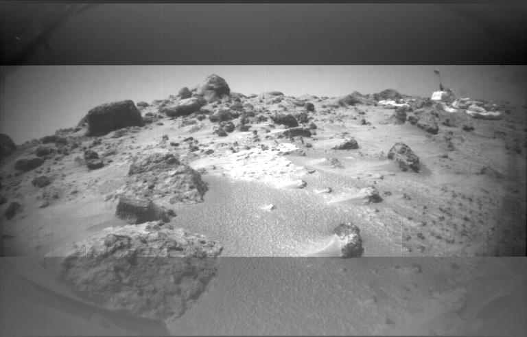
August 5 (Sol 32) |
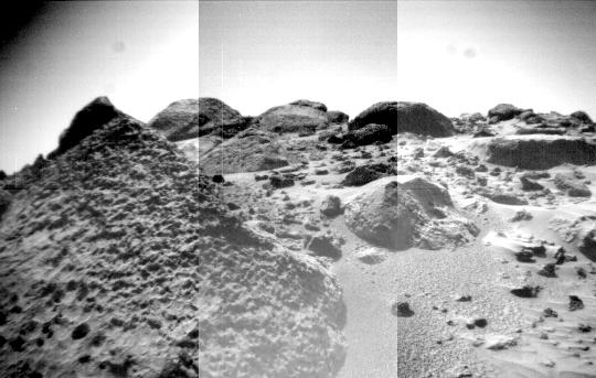
Dust Wind Tails Around RocksThis image was taken by the Sojourner rover's left front camera on Sol 32. The Pathfinder lander is at right and is about 9 meters away. Wind tails of dust are clearly seen extending from the left side of many of the small rocks in the foreground. The large rocks on the horizon at left center are the next goal of Sojourner as it continues our exploration of Mars. |
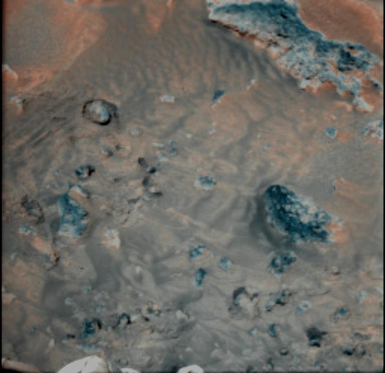 |
Wind effects on Martian soilThis false-color combination image highlights details of wind effects on the Martian soil at the Pathfinder landing site. Red and blue filter images have been combined to enhance brightness contrasts among several soil units. Martian winds have distributed these lighter and darker fine materials in complex patterns around the rocks in the scene (blue). For scale, the rock at right center is 16 centimeters (6.3 inches) long. This scene is one of several that will be monitored weekly for changes caused by wind activity. |

The missions are managed by the Jet Propulsion Laboratory, Pasadena, CA, for NASA's Office of Space Science, Washington, DC.