
September 14 (Sol 70)
|
September 14 (Sol 70) |
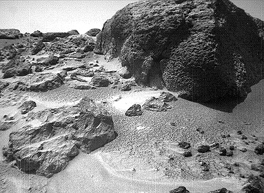
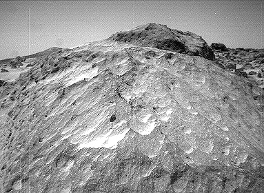
This image close-up of the rock "Moe" was taken from the Sojourner rover's left front camera on Sol 70 (September 13). Flute-like textures on the rock, possibly caused by wind abrasion, are clearly visible. |

September 14 (Sol 71) |
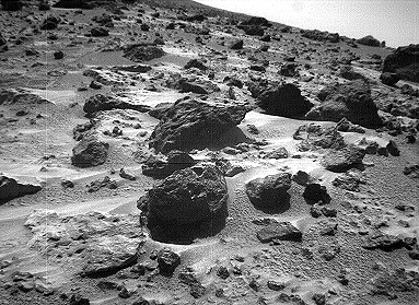
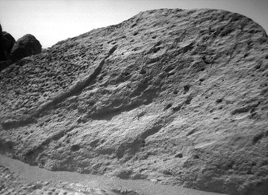
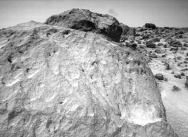
This image of the rock "Half Dome" was taken by the Sojourner rover's left front camera on Sol 71 (September 14). Pits, linear textures, and pronounced topography on the rock are clearly visible. |
 
September 15 (Sol 72) |
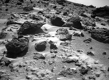
This image pair of the rock "Chimp" was taken by the Sojourner rover's front cameras on Sol 72 (September 15). Fine-scale texture on Chimp and other rocks is clearly visible. Wind tails, oriented from lower right to upper left, are seen next to small pebbles in the foreground. These were most likely produced by wind action. |

September 17 (Sol 74) |
This image taken on Sol 74 ( September 17) from the Sojourner rover's right front camera shows areas of the Pathfinder landing site never before seen. The shadow of the rover and its antenna are visible in the foreground. On the horizon at right are the Twin Peaks, about 1 kilometer away. |

September 19 (Sol 76) |
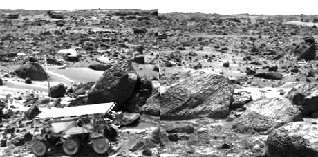
This image pair taken by the Sojourner rover's front cameras was taken on Sol 76. The "Twin Peaks" (~ 1 km away) are seen on the right horizon, as is "Big Crater" (2.2 km away) at left. This new viewing perspective shows dunes and rocks not visible from the Pathfinder lander. |
 |
This color image mosaic shows areas that have recently been traversed by the Sojourner rover. The large, prominent rocks on the right comprise the "Rock Garden." The three main rocks making up this assemblage were all analyzed by Sojourner's Alpha Proton X-ray Spectrometer (APXS). They are (from left to right) "Shark," "Half Dome," and "Moe." Other rocks examined by the APXS include "Wedge" (wedge-shaped rock in middle foreground), "Stimpy" (in front of Moe), and "Chimp" (tabular rock in middle-left background) . |

September 10 (Sol 67) |
This rover movie taken on Sol 67 shows the Sojourner rover attempting to deploy its Alpha Proton X-Ray Spectrometer (APXS) against the rock "Stimpy." In the latter part of the film, Sojourner's rear right wheel drives up the edge of the rock. The APXS was not successfully deployed against Stimpy during this attempt. This was eventually achieved on Sol 68. |

September 15 (Sol 72) |
This rover movie taken on Sol 72 shows the Sojourner rover exiting the "Rock Garden." It begins its traverse behind the rock "Wedge," drives over a small boulder, and then heads toward the tabular-shaped rock "Chimp." |

September 17 (Sol 74) |
This rover movie taken on Sol 74 shows Sojourner maneuvering around the left side of the tabular-shaped rock "Chimp." Successfully-executed rover turns are demonstrated. |
 |
Mars interior is simply modeled as a core and mantle with a thin crust, similar to Earth. Mars' size and total mass have been determined by previous missions. Given four parameters, the core size and mass and mantle size and mass can be determined. The combination of Pathfinder Doppler data with earlier data from the Viking landers has determined a third parameter, the moment of inertia, through measurement of Mars' precession rate. A fourth measurement is needed to complete the interior model. This may be achieved through future Doppler tracking of Pathfinder, since the presence of a fluid core may be detectable through its effect on Mars' nutation. The determination of the moment of inertia is a significant constraint on possible models for Mars' interior. If the core is as dense as possible (i.e. completely iron) and the mantle is similar to Earth's (or similar to the SNC meteorites thought to originate on Mars) then the minimum core radius is about 1300 km. If the core is made of less-dense material (i.e. a mixture of iron and sulfur) than the core radius is probably no more than 2000 km. |
 |
The Rotation and Orbit Dynamics experiment is based on measuring the range a Doppler to Pathfinder using the radio link. Mars rotation about it's pole causes a signature in the data with a daily minimum when the lander is closest to the Earth. Changes in the daily signature reveal information about the planetary interior, through its effect on Mars' precession and nutation. The signature also is sensitive to variations in Mars' rotation rate as the mass of the atmosphere increases and decreases as the polar caps are formed in winter and evaporate in spring. Long term signatures in the range to the lander are caused by asteroids perturbing Mars' orbit. Analysis of these perturbations allows the determination of the masses of asteroids. |
 |
This enhanced color image of the Pathfinder landing site shows the eastern horizon. The elongated, reddish, low contrast region in the distance is "Roadrunner Flats." |
 |
This is an image from the super-pan sequence. Of importance are some of the features around the rock nicknamed Barnacle Bill in the left foreground. The rock shows a "streamlined tail" composed of particles deposited by wind on the leeward (downwind) side of the rock. Also seen is a "moat" around the opposite (windward) side of the rock where either erosion (or non-deposition) of fine sediment has occurred. Mars Pathfinder scientist believe that the wind blowing over and around rocks like Barnacle Bill creates an airflow pattern wherein a buffer zone is formed immediately upwind of the rock and airflow patterns keep sediment from being deposited directly upwind of Barnacle Bill. On the downwind side, however, the airflow is complex and a small wake and tapered "dead air zone" form. Sediment can be deposited within this region, the shape of the formed deposit corresponds to the airflow patterns that exist behind the rock. Similar features have been observed at the Viking landing sites, and are thought to form under high wind conditions during the autumn and winter seasons in the northern hemisphere. This image mosaic was processed by the U.S. Geological Survey in support of the NASA/JPL Mars Pathfinder Mars Mission. |
 |
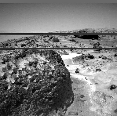
A close-up view of the rock "Moe" in the Rock Garden at the Pathfinder landing site. Moe is a meter-size boulder that, as seen from Sojourner, has a relatively smooth yet pitted texture upon close examination. Such a texture is seen on Earth on rocks that have been abraded by wind in a process that is analogous to sand blasting. This view of Moe shows two faces on the rock, one (left side of the rock) facing north-northeast and the other (right side) facing east. These two faces are thought to have been pitted and fluted by strong, "sand"-carrying winds from the northeast. |
 |
This pair of images shows a broad view (upper image) and detailed close-up view (lower image) of the disturbed surface near and on Mermaid Dune. Seen slightly right of center in the upper image are two diggings by the rover's wheel. The uppermost rut is in the surface away from Mermaid and is considered to be typical of the surface at the landing site. The closer rut represents the surface at the base of Mermaid on the upwind side. The lower image is an enlargement of the disturbed Mermaid sediments plus those of the underlying substrate; that is, the ground upon which the dune lies. Seen in the close-up are at least two types of sediment, one that seems to be approximately 1.4 cm thick and forms piles with sides sloping at approximately 35 degrees, and another at least 3 cm deep composed of sediment that has a characteristic slope of 41 degrees when piled. It is apparent in the images that there is a size range of sediment present in the rut, sediment that ranges from a few millimeters in size down to below the resolution of the camera. |
 |
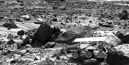
This is an image of the rover Sojourner at the feature called Mermaid Dune at the MPF landing site. Mermaid is thought to be a low, transverse dune ridge, with its long (approximately 2 meter-) axis transverse to the wind, which is thought to come from the lower left of the image and blow toward the upper right. The rover is facing to the lower left, the "upwind" direction. The rover's middle wheels are at the crestline of the small dune, and the rear wheels are on the lee side of the feature. A soil mechanics experiment was performed to dig into the dune and examine the sediments exposed. |

September 13 (Sol 70) |
The rock "Stimpy" is seen in this close-up image taken by the Sojourner rover's left front camera on Sol 70 (September 13). Detailed texture on the rock, such as pits and flutes, are clearly visible. |
 |
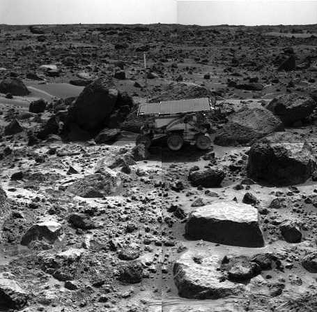
This image was taken by the Sojourner rover in the area behind the "Rock Garden" at the Pathfinder landing site and gives a view of the Martian surface not seen from the lander. Of note here are several dune-like ridges in the foreground. These features are less than a meter high but several meters wide. They are thought to be created by surface winds blowing right to left (approximately northeast to southwest). These features are called dunes, because of their asymmetry, although the rover has not examined the sediment within them. Such sediment on Earth would be sand-size grains less than 1 millimeter in diameter. |
 |
This is a representation of sediment tails noted at the Mars Pathfinder landing site. The arrows in the figure represent the inferred downwind direction, based on our understanding of the deposition of very fine sediment around surface rocks. The inferred wind direction therefore, is from the northeast blowing toward the southwest. This wind trend matched that of light and dark "streaks" of sediment in and around Martian craters in the region that have were seen by the Viking spacecraft. The detailed map was prepared by Mars Pathfinder scientists from Arizona State University on a base image created by MPF scientists from the NASA Ames research facility. |

September 15 (Sol 72) |
This stereo anaglyph view of the rock "Chimp" was taken with the Sojourner Rover forward stereo cameras on sol 72 of the Mars Pathfinder mission. |

September 13 (Sol 70) |
This stereo anaglyph of the rock "Yogi" is a portion of an image taken by the Sojourner rover on Sol 70. Much of Yogi visible in this image cannot be seen from the perspective of the Pathfinder lander. To view this image in stereo, use glasses with a red left eye and blue right eye. |

September 19 (Sol 76) |
This stereo Sojourner rover image taken on Sol 76 shows foreground dunes and, on the horizon, the rim of "Big Crater" (left, 2.2 km away) and the "Twin Peaks" (right, about 1 km away). To see this image in 3-D, use glasses with a red left eye and blue right eye. |

September 18 (Sol 75) |
This stereo Sojourner rover image taken on Sol 75 shows foreground rocks and, on the horizon, "North Peak" (0.86 km away). To see this image in 3-D, use glasses with a red left eye and blue right eye. |
 |
The rock "Shark" is seen close-up in this stereo Sojourner rover image. To view this image in 3-D, use glasses with a red left eye and blue right eye. |
 
September 23 (Sol 80) |
This stereo image pair taken on the morning of Sol 80 (September 23) shows the Sojourner rover with its Alpha Proton X-ray Spectrometer (APXS) deployed against the rock "Chimp." On the left horizon is the rim of "Big Crater," 2.2 km away. |

September 16 (Sol 73) |
This sequence of images shows the Pathfinder upper wind sock on the morning of Sol 73 (September 16). The interval between frames is one second. There is no obvious movement of the sock, indicating little or no wind at this elevation (about 1 meter above the surface). At other times during the mission, deflections of this and two lower wind socks have been used to estimate characteristics of the wind speed boundary layer profile. |
 
September 17 (Sol 74) |
This stereo image pair taken on the afternoon of Sol 74 (September 17) shows the Sojourner rover behind the rock "Chimp." Sojourner is now a record 12.3 m from the lander. |
 
September 17 (Sol 74) |
These two views of the rock "Chimp" were acquired by the Sojourner rover's right front camera on Sol 74 (September 17). A large crack, oriented from lower left to upper right, is visible in the rock. A dark crust appears to cover Chimp in some areas whereas other parts of the rock have a lighter shading. A boundary between the two regions is clearly seen in the upper left part of Chimp. |
 
September 18 (Sol 75) |
This stereo image pair shows the Sojourner rover behind the large rock "Chimp" near noontime on Sol 75 (September 18). The rover's middle right wheel is raised above the surface. Sojourner is over 12 m from the lander, a mission record. |
 
September 15 (Sol 72) |
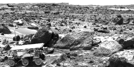
This stereo pair image mosaic shows the Sojourner rover near the large rock "Chimp" on the afternoon of Sol 72 (September 15). Prior to the acquisition of these images, Sojourner successfully traversed the terrain between Chimp and the "Rock Garden," an assemblage of large rocks to the right of this mosaic. |
September 15 (Sol 72) |
This stereo image pair of the rock "Chimp" was taken by the Sojourner rover's front cameras on Sol 72 (September 15). Fine-scale texture on Chimp and other rocks is clearly visible. Wind tails, oriented from lower right to upper left, are seen next to small pebbles in the foreground. These were most likely produced by wind action. |
September 15 (Sol 72) |
This stereo image pair, taken on Sol 72 (September 15) from the Sojourner rover's front cameras, shows areas of the Pathfinder landing site never before seen. The large rock on the right is "Shark." The knob on the horizon is the summit of a peak 1.7 km away. The area to the left of Shark cannot be seen from the lander, demonstrating the rover's unique ability to navigate and study distal regions of the landing site. |
September 14 (Sol 71) |
This stereo image pair taken on the afternoon of Sol 71 (September 14) shows Sojourner leaving the "Rock Garden," an assemblage of large rocks behind and to the right of the rover. Sojourner's last target was the rock "Stimpy," seen at the far right. |
September 14 (Sol 71) |
This stereo image pair of the rock "Half Dome" was taken by the Sojourner rover's front cameras on Sol 71 (September 14). Pits, linear textures, and pronounced topography on the rock are clearly visible. |
September 13 (Sol 70) |
This stereo image close-up of the rock "Moe" was taken from the Sojourner rover's front cameras on 70 (September 13). Flute-like textures on the rock, possibly caused by wind abrasion, are clearly visible. |
September 13 (Sol 70) |
The rock "Stimpy" is seen in this stereo close-up image pair taken by the Sojourner rover's front cameras on Sol 70 (September 13). Detailed texture on the rock, such as pits and flutes, are clearly visible. |

September 14 (Sol 71) |
This image mosaic of part of the "Rock Garden" was taken by the Sojourner rover's left front camera on Sol 71 (September 14). The rock "Shark" is at left center and "Half Dome" is at right. Fine-scale textures on the rocks are clearly seen. Broken crust-like material is visible at bottom center. |
September 9 (Sol 66) |
This stereo image pair shows the Sojourner rover in the middle of the afternoon on Sol 66 (September 9). The rover has backed away from the rock "Moe" (to the right of the rover) after measuring its composition with the Alpha Proton X-Ray spectrometer. The next target for Sojourner, the rock "Stimpy," is in front of Moe. |
September 11 (Sol 68) |
This stereo image pair shows the Sojourner rover's Alpha Proton X-ray Spectrometer (APXS) deployed against the rock "Stimpy" on the afternoon of Sol 68 (September 11). The two rocks behind the rover were previously analyzed by the APXS. |
September 9 (Sol 66) |
This composite image shows particles adhering to magnetic target arrays on the Pathfinder lander. Each array consists of five magnets that increase in magnetic filed strength as seen from left to right. The red material forming a bull's-eye pattern on the arrays is magnetic Martian dust deposited from the atmosphere. An increase in magnetic dust deposition from Sol 10 to Sol 66 is clearly evident. By analyzing the patterns of dust on the various magnets, scientists are able to measure the dust's magnetic strength and infer its composition. |
September 8 (Sol 65) |
This color image shows the Sojourner rover's Alpha Proton X-ray Spectrometer (APXS) deployed against the rock "Moe" on the morning of Sol 65. The rock behind the rover is "Half Dome", which was previously measured by the APXS. |
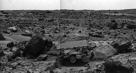 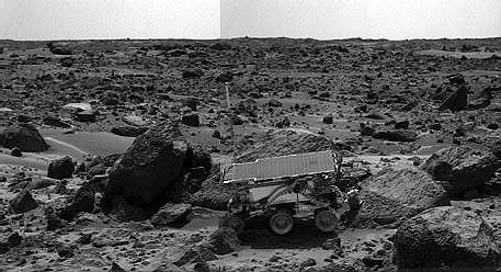 |
Left and right images of Sojourner traversing near Half Dome. |

The missions are managed by the Jet Propulsion Laboratory, Pasadena, CA, for NASA's Office of Space Science, Washington, DC.